


A flood warning system based on ultrasonic sensors and wireless technology
1 Introduction
Flood disaster mainly refers to the flood caused by a large amount of precipitation that brings disasters and losses to the normal production and life of human beings. Flood disaster is characterized by complexity, uncertainty and dynamics [1]. Because of the particularity of geography and geological environment, the area along the river of Beijing is a flood disaster prone area. Flood disasters may occur at any time, bringing adverse effects on society, especially on people living around rivers [2]. Therefore, it is necessary to design a system to provide early warning to the public before a flood disaster occurs. The purpose of the flood early warning system is to reduce the extent of the impact of the flood and the material losses suffered by society. At present, there are many types of flood early warning systems. For example, Li Lina et al. [3] took Haizhou District of Lianyungang City as an example and proposed reasonable water and rain conditions and video monitoring stations in this area on the basis of establishing corresponding early warning systems and mechanisms through research. The warning system needs a location as a water level reference, which can be either a lock or a dam, since each lock or dam has a different state of water storage. This paper introduces a flood warning system which uses wireless technology and short message as the medium of information transmission. The system uses three sensors to improve the measurement accuracy, including two ultrasonic transmitters to measure the water level and one water flow sensor to measure the flow.
2 Warning Status
Usually, different states of flood warning can be obtained through the analysis of water station information of rivers. Each reservoir has different warning criteria, depending on the depth of the river. There are four types of warning states: (1) Standby -W state with no significant increase in traffic; (2) stand-by - democratic state, when rainfall causes an increase in the amount of water in the sluice, but the situation is still not critical or dangerous, however, if the official declaration of a warning stand-by democracy, the public should remain alert and make all preparations from the possibility of flooding; (3) In the stand-by -n state, rainfall leads to an increase in river discharge; (4) Standby -I state, water flow remains in standby -n state for more than 6 hours, or even more serious situation.
3. Test methods and contents
The prototype test consists of two HC-SR04 ultrasonic sensors as water level detection sensors, a YF-S201 flow sensor to measure flow, a microcontroller as control system, wireless transmitter and receiver module, GSM sim900A module to send flood information and a buzzer as water level indicator.
3. 1 Characteristics of ultrasonic sensor
The characteristic test of ultrasonic sensor is shown in Figure 1 to determine the effective range of the sensor and the resolution of the ultrasonic sensor [5]. The distance between the two sensors is 14cm~250cm, and the maximum relative error is 4.33%. The minimum distance detected by the sensor is 0.5cm, and the maximum relative error is 1.2%. According to prototype scale, the water level conditions under different standby states were optimized, and the optimal prototype ratio was 1:5. This ratio will be used to adjust the distance between the sensor and the water surface.
3. 2 Experimental design
Based on the water level M40cm in the standby -I state, the ratio of 1:5 is adopted. Therefore, a reservoir with a size of 30cmX40cmx50cm was designed for the experiment. Both ultrasonic sensors are mounted on a 60cm stick 10cm from the highest water surface. Table 1 lists the sensor's distance to the water surface in each state.
The prototype involves two systems: a monitoring system as a data transmitter and a remote alert system as a receiver. A pair of Xbee Series 2 modules are used for telecommunication. Therefore, two programs are used on this prototype, namely the transmitter on the monitoring system and the receiver on the remote alarm system.
4 Test results and analysis
4.1 Ultrasonic sensor measurement
The measurement of reservoir water surface by ultrasonic sensor system is carried out under three different conditions: Condition 1 uses a water source; Condition 2: Use two water sources; Condition 3 Use a water source and a dynamic water surface. The water surface in condition 1 and condition 2 tends to be stable, while the water surface in condition 3 is fluctuating and unstable, so it is closer to the actual condition. The measurement results of sensors 1 and 2 under all three test conditions are shown in Figure 2.
Both sensors can work normally and detect changes in the water level of the reservoir, but the measurement error under condition 3 is larger than that under other conditions. Because, when the surface of the object is basically flat, the sensor reading will be more accurate, that is, ultrasonic sensors on hard and smooth surfaces can get the most accurate reading. Relatively rough or soft surface will reduce the ultrasonic sensor's working distance and measurement accuracy. Another factor affecting sensor measurement is the distance between the sensor and the object. The increase of the distance between the sensor and the target will prolong the response time of the sensor to send and read the result, so that the echo signal received by the sensor becomes weaker and weaker. Conversely, the closer the sensor is to the object, the stronger the echo signal it produces.
Measurement relative error of two sensors under different measurement conditions in the standby -I state. It can be seen that for moving water surface, the measurement error of the sensor is small. In general, the use of two ultrasonic sensors will improve the reading accuracy of the sensor, especially in the case of unstable water surface conditions, the reading of water level will be more accurate.
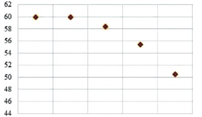
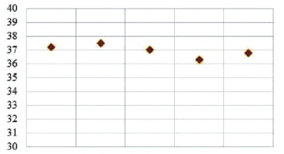
In the prototype, flow sensor is used to provide water flow stability information, and the measurement results of the sensor are shown in Figure 3. In FIG. 3(a), the flow decreases with the increase of water level. On the other hand, Figure 3(b) shows that the current water flow is relatively stable, which means that the output of the sensor tends to be stable in the range of 36.3ml ~ 37.8ml, and the flow through the sensor decreases or increases depending on the flow of the water source. YF-S201 flow sensor works based on the Hall effect phenomenon. Water flowing through the sensor will make the impeller in the sensor rotate. The rotation of the impeller will generate a magnetic field on the coil of the water flow sensor. A decrease or increase in the flow value read by the sensor has no effect on the water level change, because the water flow does not indicate a change in the alarm state, it simply provides additional information about the flow. If the flow of water suddenly rises sharply and remains high, it can be a warning of flooding.
(a) Unstable water flow
(b) Stabilization of water flow
4. 3 Xbee module test
The test was conducted indoors without a barrier and outdoors with a wall barrier, and the results demonstrated wireless capability. The Xbee module works well under barrier conditions. For barrier conditions,Xbee can only receive data as far as 24.3m.
4. 4 GSM sim900A Test
The test was conducted on five different mobile phone numbers from different carriers, calculating the speed of receiving messages from the time the system emits an "A" character on the display.
The fastest time to receive a text message based on the test was &2s and the longest was 33.3so The time to send a text message was not always constant. When the water level monitoring system sends this message, the phone number receiving the message receives a text message with the standby -I status and a water level height report.
4.5 Overall system test results
Test against the design software created to determine the overall performance of the system. Each distance change specified according to the standby state is considered to operate correctly as the software is designed. Table 4 shows that the tests performed match the design of the software. The prototype can work under the condition of unstable water level. The accuracy of ultrasonic sensor 1 and ultrasonic sensor 2 reaches 97.6%. The use of multiple sensors can improve the accuracy of the prototype, especially under moving surface conditions. The combination of wireless technology, Xbee and GSM module, improves the transmission efficiency of early warning information.
5 Conclusion
The flood disaster warning system combined with wireless technology, Xbee and GSM module has good test results, which improves the transmission efficiency of alarm information. Ultrasonic sensors can effectively measure the state of moving water surface. At the same time, the measurement of flow sensor can be used as additional information of flow change in flood disaster warning system.
Reference literature
[1] Wang Haiying. Design of statistical system of flood disaster characteristics in different regions based on precipitation big data [J]. Journal of Catastrophology,20,35(04) : 29-32.
[2] Cheng Xianfu, Zhang Haiyu, Hao Dandan. Risk analysis of flood disaster in Anhui River Region [A]. Innovative Theory and Method of Risk Analysis and crisis Response -- Proceedings of the Fifth Annual Meeting of Risk Analysis Professional Committee of China Disaster Prevention Association [C]. Risk Analysis Committee of China Disaster Prevention Association, 2012:4.
[3] Li Lina, Xie Jing, Sheng Siyuan. Research on the layout of flood warning system based on small watershed [J]. Jiangsu Water Resources,2020(02) : 48-51.
[4] Li Yan, Zhang Min. Automatic water level Control System based on Ultrasonic Sensor [J]. Microcomputer Information,2009,25(13) : 134-136.
[5] FENG Yang. Design of Water Tank Level Controller Based on Ultrasonic Sensor [J]. Journal of Weinan Normal University,2013,28(09) : 82-84.